Posts

Showing posts from October, 2011

Purisima Creek Redwoods, Half Moon Bay

Image
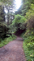
This week we decided to hike the Purisima Creek Redwoods Open Space Preserve, near Half Moon Bay. You can reach the park by taking 92 West to Half Moon Bay. Then you take Higgins Canyon exit at 1 South, which leads a very narrow road for 4.2 miles to the trailhead on the left side of the road. This park has 4 entrances. We chose the trailhead at Higgins Canyon entrance. This parking lot only caters for 8 cars at this entrance. There are many trails options within the park. We decided to do a loop hike including Bald Knob (2102 feet elevation). The trailhead is at 400 feet elevation. The weather was cloudy and little chillier with temperatures in mid 50s. We started our trek with a flat mile long Purisima Creek trail. The landscape was extremely green. This park gives you a feeling that you are hiking in a dense rain forest. The stroll was along the water stream was extremely pleasant. My son and me crossed a slippery fallen tree bridge over the water stream for fun.

Mt. Rose, Nevada

Image
After hiking many 10+ miles trails in bay area, we were itching to hike in Sierras. We decided to hike Mount Rose (10776 feet elevation) near Lake Tahoe on Nevada side. It is second tallest peak in the Tahoe basin. This hike is around 11 miles with approximately 2400 feet elevation change. Normally, this would have been a regular hike for us, but the weather made this hike very interesting. Just 2 days before our scheduled hike, there was a big storm, which dumped more than a foot of snow above 6000 feet elevation level. We reached the Mt. Rose trailhead (8900 feet elevation) at 11.00am on Saturday. Weather was sunny with temperatures in high 40s with wind around at 10 mph. The trail was all covered with snow from anywhere between 6 inches to a foot. Some places the snow was soft powder and some places it was slushy. It made very difficult taking each step. We soon realized that this would be a challenging hike. We started on a direct route up by Mt. Rose Summit trail. This trail c

Mt. Diablo State Park

Image
Surprisingly for the first time after summer break we had weather that was in the low 70s on the first Sunday of this fall. We decided to take advantage of good weather and hike up challenging Mt. Diablo Summit. Mt. Diablo height is 3849 feet. The hike starts at 400 ft level. We reached the North entrance of the park at 9.15 am. We checked the map at the ranger station, where the ranger suggested us to take gradual hike route Coulter pine trail instead of usual Mitchell Canyon route.   After stretching a bit, 3 of us started our 7-mile uphill hike. Since the weather was nice and initial slope was mild, we were covering the ground faster. Soon, we took the fire road, a downhill path; causing us to loose whatever height gain we had gained earlier. After a half-mile trail on fire road, we soon reached the back creek tail. This was a very steep uphill hike for next 2.5 miles. Even though this trail is in open, it is a very narrow trail through 5-6 feet tall shrubs.   As we